Image Surveys Ltd
Background
The drone technology industry is experiencing rapid growth, driven by advancements in aerial imaging and data collection capabilities. Image Surveys Limited, founded by Mark Carr, has positioned itself as a market leader by offering high-quality drone solutions tailored to various client needs, including surveys, inspections, mapping, and emergency work.
With over 23 years of experience, Mark Carr has leveraged his expertise to continuously innovate, ensuring Image Surveys Ltd remains at the forefront of technological advancements. The company’s pilots are accredited by the Civil Aviation Authority (CAA), ensuring compliance with industry standards and enhancing the safety and efficiency of their operations.
Challenge
The market for drone technology solutions is projected to grow from $28 billion in 2023 to $166.7 billion by 2031 (USD). This growth is fuelled by the increasing adoption of drones across various industries, including construction, agriculture, and emergency services. To capitalise on these market trends.
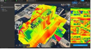
The initial meetings between Image Surveys and the VEC (Virtual Engineering Centre) highlighted the company’s ambition to expand its service offerings by integrating photo and thermal aerial surveys. This integration aims to automatically generate 3D models that combine both photographic and thermal data, addressing a growing market demand for comprehensive data solutions.
The collaboration aims to enhance the company’s technical capabilities, enabling them to offer more sophisticated services to their clients. By leveraging the latest hardware and software solutions, Image Surveys is poised to capture a larger market share and drive revenue growth.
Solution
The VEC would explore several available drone solutions that would match the technical desires and needs of Image Survey and adhere to strict safety regulations, combined with the consideration for their investment allowance and restrictive budgets.
Each model identified as a potential match was closely evaluated to ensure the device would offer precise data collection capabilities and adaptability to various surveying conditions.
In addition to hardware selection, the VEC identified suitable software tools to process and visualise the data captured during drone missions including capabilities in 3D model reconstruction, thermal image analysis, and data integration.
These tools enable Image Surveys to deliver high-quality outputs tailored to client requirements, enhancing their competitive edge and offering in the market.
The project timeline was specifically structured to ensure seamless integration of the new technologies into Image Surveys’ existing operations, focusing on minimising disruptions and maximising efficiencies.
Impact
The implementation of advanced drone technologies and software tools had a significant impact on Image Surveys Limited’s operations. The integration of advanced software tools has improved the accuracy and efficiency of data processing. The newly acquired ability to generate high-precision 3D models and thermal analyses allows Image Surveys to deliver more detailed and actionable insights to their clients.
This has enhanced the company’s reputation for quality and innovation, positioning them as a leader in the drone technology solutions industry.
Financially, the project is expected to generate cost savings for the company by streamlining data collection and processing workflows, reducing the time and resources required for each mission.
The enhanced capabilities of the solutions identified and implemented enable Image Surveys to offer more comprehensive services, attracting new clients and increasing revenue.
The use of drones for surveys and inspections reduces the need for traditional methods that often involve significant carbon emissions. By eliminating the need for scaffolding and other equipment, Image Surveys can conduct operations more sustainably, contributing to a reduction in their overall environmental footprint.
Click here for the downloadable case study.
